Return to About Us Home Page
Click on Image to Enlarge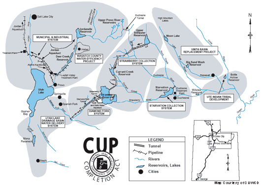
The Central Utah Project authorized development of six different units--the
Vernal, Jensen, Ute Indian, Uintah, Upalco, and Bonneville. The Bonneville
unit, the largest unit, is located on both sides of the Wasatch Mountains
in central and northeastern Utah. The portion of project area east of the
mountains is in the Uinta Basin, a segment of the Colorado River Basin;
and the portion west of the mountains is part of the Bonneville Basin,
a segment of the Great Basin, which has no outlet to the sea. Parts of
ten counties are included in the Bonneville Unit area--Uintah, Duchesne,
Wasatch, Summit, Utah, Salt Lake, Juab, Garfield, Piute and Sanpete.
The Bonneville Unit consists of a transbasin diversion of waters tributary
to the Colorado River into the Bonneville Basin and Utah’s Wasatch Front.
It includes facilities to collect water from Duchesne River system streams,
to store and regulate collected water and to release it through the Wasatch
Mountains as needed into the Bonneville Basin. The unit is divided into
six systems: Starvation Collection System, Strawberry
Aqueduct & Collection
System, Ute Indian Tribal Development, Municipal
and Industrial System,
Diamond Fork System and the proposed Utah
Lake Drainage
Basin Water Delivery System.
These systems contain a vast network of reservoirs, aqueducts, tunnels
and canals, pipelines, pumping plants and conveyance facilities that develop
water for irrigation, municipal and industrial use and power production.
Starvation Collection System: This system develops water for
municipal and irrigation uses and provides flood control, recreation and
fish and wildlife measures in the Duchesne area. Starvation Reservoir,
located on the Strawberry River, provides regulatory storage.
Strawberry Aqueduct & Collection System (SACS): This
system diverts
flows from Rock Creek and eight other Duchesne River tributaries through
approximately 40 miles of tunnels and aqueducts for storage in Strawberry
Reservoir. Upper Stillwater Reservoir serves as a regulating reservoir
at the beginning of the Strawberry Aqueduct to provide temporary storage
of high spring flows. Currant Creek Reservoir diverts water from Currant
Creek and five of its smaller tributaries into the aqueduct.
[Click here to
learn about mitigation projects associated with this system]
Ute Indian Tribal Development: Bottle Hollow Reservoir was constructed
to compensate the Ute Indian Tribe for economic losses associated with
reduced stream flows.
Municipal and Industrial (M&I) System: This system consists
of Jordanelle Dam and Reservoir, located about six miles north of Heber
City, and the Alpine and Jordan aqueducts which divert flows from the Provo
River near the bottom of Provo Canyon. This system provides municipal and
industrial water to Salt Lake, Utah, and Wasatch Counties and supplemental
irrigation water to Summit and Wasatch Counties.
[Click here to learn
about mitigation projects associated with this system.]
Diamond Fork System: This system conveys waters diverted from
the Uinta Basin and stored in Strawberry Reservoir to the Wasatch Front.
It delivers water to Utah Lake for the Municipal and Industrial system
water exchange, for irrigation in the Spanish Fork area, and for the Strawberry
Valley Project, which had been constructed in the early 1900's. The combined
deliveries of the Strawberry Valley Project and CUP amount to approximately
163,400 acre-feet per year. (An acre foot of water is the approximate amount
needed to supply a family of four water for one year.)
[Click here to learn
about mitigation projects related to this system.]
Utah Lake Drainage Basin Water
Delivery System (ULS):
This system will complete the Central Utah Project. It is the last link in the complex system of dams, reservoirs, pipelines and tunnels that will bring water from eastern Utah’s Colorado River basin to populous Wasatch Front cities including Salt Lake City to the north and south to Utah County cities. The ULS consists of buried pipelines extending from the terminus of the Diamond Fork System at the mouth of Diamond Fork Canyon in Utah County, down the Spanish Fork Canyon to the western side of the Wasatch Mountains. From there a series of pipelines will travel both north and south to deliver water to CUP customers. This system will deliver 101,900 acre-feet of CUP water for irrigation and municipal and industrial uses to Utah communities. [Click
here to learn about mitigation proposals for this system.] |