|
The Diamond Fork watershed was used to transport water from
Strawberry Reservoir to agricultural lands in Utah Valley since
the Strawberry Valley Project was constructed in the early 1900s.
The transbasin diversion of water from Strawberry Reservoir through
the Strawberry Tunnel into Sixth Water Creek and Diamond Fork Creek
provided a substantial water supply, but artificially high flows
caused extensive deterioration of natural stream channels in the
watershed.
Between 1916 and 2004, streamflow in the Diamond Fork was often high enough to mobilize the streambed for months at a time. In many areas, severe downcutting of the channel occurred, and the stream was effectively detached from its floodplain. In other locations, especially in the lower reaches, these high flows caused constant mobilization of the streambed material. The result was an extremely wide braided channel that was constantly shifting and moving. The activity of the channel bed prevented establishment of riparian vegetation in many areas because the surfaces where trees were germinating were reworked before the small trees could establish a firm root system.This all resulted in severely limited fish production,
loss of soils, loss of riparian and wetland habitat, and greatly
reduced recreational experiences.
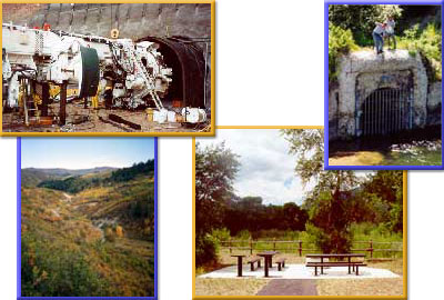
Completion of the Diamond Fork Water Delivery System in 2005,
provides opportunities to reduce damaging high flows by diverting
them through a tunnel and pipeline system, which should help
stabilize stream banks and improve riparian and fisheries resources.
(For a description of the Diamond Fork Water Delivery System, click here to link to Diamond Fork Mitigation.)
The Commission's program for Diamond Fork places
priority on completing unfulfilled mitigation responsibilities
associated with the transbasin diversion of water from the Uinta Basin
through the Diamond Fork System.
To better understand the dynamics of the watershed, the Commission and U.S. Forest Service completed an Area Assessment in 1999 that evaluated the streams, vegetation and wildlife before European settlement, impacts of human use on these resources, and their current status. It identified and presented causes for resources operating outside a properly functioning condition. The Assessement serves as a foundation for mitigation activities planned in Diamond Fork. [Click here to download the 1999 Diamond Fork Area Assessment]
Integral to the program is restoration of Sixth Water and Diamond Fork Creeks, from Three Forks to the mouth of Spanish Fork River. The Commission is assessing stream channels, riparian vegetation and biotic communities as part of its planning approach. In addition, the Commission is managing acquired mitigation lands on lower Diamond Fork to ensure stream and riparian restoration efforts are realized and angler access is provided. [Click here to learn more about Diamond Fork and Sixth Water Aquatic and Ripairan Habitat Restoration.]
Diamond Fork and Sixth Water Creeks water quality monitoring is an environmental commitment associated with the water delivery system. The Commission and Central Utah Water Conservancy District have conducted water quality and water temperature monitoring in Sixth Water and Diamond Fork since 1996. [Click here to learn more about the Water Quality monitoring.]
Construction of recreation facilities in Diamond Fork was another unfulfilled mitigation commitment; however, it is now completed. The Commission and Spanish Fork Ranger District of the Uinta National Forest cooperated to rehabilitate and combine the old Diamond and Palmyra campgrounds. Individual campsites and loops within the 100-year floodplain were moved to a higher terrace to protect riparian vegetation and facilitate future stream restoration. The Diamond Campground was completed in the summer of 2000. Group-site facilities were removed from the campground to be construction in a more suitable location, in a heavily disturbed area in the Monks Hollow vicinity. The group-site campground was completed in the summer of 2008. Dispersed camping has been closed from Spanish Fork to Sawmill Hollow; dispersed camp sites above Sawmill have been inventoried and closed where resource damage was a problem. A day-use area was constructed at Red Ledges and trailhead improvements made at Monks Hollow, Dry Canyon, Three Forks and Sawmill Hollow. Parking areas for angler access have been constructed at eleven sites from Spanish Fork to Monks Hollow. Restrooms are available at seven sites from Diamond Fork Campground to Sawmill Hollow.[Click here to link to information on recreational opportunities in the Uinta National Forest.]
|