 One component of UBRP is stabilization
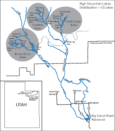
of thirteen water-storing reservoirs, built between 1910 and 1930. The reservoirs lie in the Ashley National Forest
in three separate basins - Brown Duck, Garfield and Swift Creek Basins - in what is now the High Uintas Wilderness Area.
Nine of these reservoirs (Bluebell, Drift, Superior, Five Point, Water Lily, Farmers, Deer, White Miller and East Timothy)
are within the Upper Yellowstone Watershed and four reservoirs (Clements, Brown Duck, Kidney and Island) are within the Lake Fork Drainage (see map, left). One component of UBRP is stabilization
of thirteen water-storing reservoirs, built between 1910 and 1930. The reservoirs lie in the Ashley National Forest
in three separate basins - Brown Duck, Garfield and Swift Creek Basins - in what is now the High Uintas Wilderness Area.
Nine of these reservoirs (Bluebell, Drift, Superior, Five Point, Water Lily, Farmers, Deer, White Miller and East Timothy)
are within the Upper Yellowstone Watershed and four reservoirs (Clements, Brown Duck, Kidney and Island) are within the Lake Fork Drainage (see map, left).

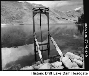
The historic dams at these reservoirs embodied a style and type of architecture associated with the formative years of water
impoundment in the High Uintas. They are considered nationally significant cultural resources and are eligible to the National
Register of Historic Places based upon age and integrity, as well as upon National Register criteria. The dams were evaluated
as significant individual resources, as well as components of a much larger irrigation network. They are monuments to the pioneering efforts of early irrigation companies to
increase agricultural potential of the Uinta Basin.
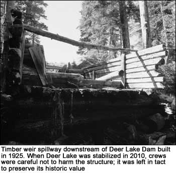
 While culturally important, the dams' remote location in a wilderness area made maintenance difficult, and substantial deterioration and eventual risk of catastrophic failure required substantially altering the historic dams and stabilizing the reservoirs to no-hazard levels. To mitigate for this loss, parts of each historic dam remain in place, preserving them as part of the local heritage. In addition, this website and interpretive displays located at trailheads leading to the stabilized lakes were created to document and capture the dams' historic contribution and importance. We refer to the above aspect of UBRP as the "High Mountain Lakes Stabilization Project." While culturally important, the dams' remote location in a wilderness area made maintenance difficult, and substantial deterioration and eventual risk of catastrophic failure required substantially altering the historic dams and stabilizing the reservoirs to no-hazard levels. To mitigate for this loss, parts of each historic dam remain in place, preserving them as part of the local heritage. In addition, this website and interpretive displays located at trailheads leading to the stabilized lakes were created to document and capture the dams' historic contribution and importance. We refer to the above aspect of UBRP as the "High Mountain Lakes Stabilization Project."
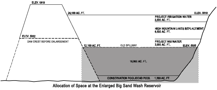
Water rights owned by the Moon Lake Water Users Association were transferred from the High Mountain Lakes downstream to the enlarged Big Sand Wash Reservoir near Roosevelt, Utah. This enables continued water delivery for agricultural and other purposes. Stabilization of the reservoirs began in 2006 and was completed in 2010. Water flow originating in the upper watersheds will return to natural runoff patterns, and operation and maintenance impacts associated with the historic dams will no longer be required. 
|